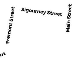
7 SIGOURNEY ST
Owner Information
MAILHOT, ANDRE G
7 SIGOURNEY ST
OXFORD, MA 01540 1943


Property Details
7 SIGOURNEY ST is classified as a Mixed Use (Primarily Residential, some Commercial) (Ranch).
The primary structure on this property was built in 1920. There are 2,722ft2 of built area within this property. There is 1,354ft2 of residential/living space within this property. This property is listed as having 6 rooms.
7 SIGOURNEY ST is valued at $352,100. The land is valued at $88,800 and the structures are valued at $263,300.
The most recent deed for 7 SIGOURNEY ST is recorded at the local registrar in Book 49951, Page 398. 7 SIGOURNEY ST was last sold on Wednesday, November 14, 2012 for $100.
Assessment data from fiscal year 2021.
Flood Data
According to the FEMA National Flood Hazard Layer, this property does not appear to be in a flood zone. It may also be in an area not yet reviewed. Nonetheless, confirm this information prior to taking any action.
To view the flood hazards around this property, create a FEMA "Firmette" Map of the area around 7 SIGOURNEY ST.
Broadband Internet Providers
| Provider | Type | Bandwidth (mbps) | |
|---|---|---|---|
| Crown Castle Fiber | Fiber | 0 | 0 |
| GCI Communication Corp. | Satellite | 0 | 0 |
| Charter Communications Inc | Cable | 940 | 35 |
| Verizon New England Inc. | DSL | 15 | 1 |
| VSAT Systems, LLC. | Satellite | 2 | 1 |
| HughesNet | Satellite | 25 | 3 |
| Viasat Inc | Satellite | 100 | 3 |
Broadband service provider data from December 2020.